I wrote the post below yesterday but we lost internet access, and I cant be bothered re-editing it! Just imagine I posted it yesterday ;o) Anyway, we are now anchored off Three Hummock Island, where we will probably stay for a day or two.
I'm writing from Shepherds Bay on Hunter Island, after (pretty much) completing our crossing of Bass Strait! We are only half a day from Mainland Tassie, and from here on in it should be a piece of cake - he he ;o)
I'm writing from Shepherds Bay on Hunter Island, after (pretty much) completing our crossing of Bass Strait! We are only half a day from Mainland Tassie, and from here on in it should be a piece of cake - he he ;o)
We have no phone reception here, but have managed to get internet access by hoisting the wireless device to the top of the mast. This has allowed us to spend the afternoon listening to the JJJ Hottest 100 and having our own little Australia Day party!
As Michael said, we left Port Fairy on the evening of 17 January to cross the first half of the notorious Bass Strait. After an uncomfortable but otherwise uneventful 24 hours we anchored in the lee of New Year Island, before heading to Currie Harbour on King Island the following morning. We had so been looking forward to visiting this very remote place, with its promise of the best beef, famous cheeses, seafood and tragic maritime history. We got a rather “cool” welcome from the local fisherman as we made the tricky entrance into the harbour dotted with nasty reefs. Tourism is not the biggest export on King Island, and obviously yet another boatload of outsiders taking up space on their wharf was more of a nuisance than a welcome addition! The fishos directed us to raft up against one of the big steel cray boats, which was fine by us, it just meant clambering over their decks to get up on to the wharf.
We eagerly hiked up the hill to the town of Currie which was a great little town – really friendly and home to a fantastic supermarket, butcher and bakery – home of Michael’s dream $12 crayfish pies.
We decided to cough up the dollars and hire a car for the next two days which was definitely worth it as we were able to explore every corner of the island and get a real sense of the place. We visited “that” cheese factory, explored the Martian remnants of a 7000 year old calcified forest and learnt heaps about the tragic maritime history of the island. Michael went snorkeling in Currie Harbour and caught a beautiful abalone, but unfortunately the conditions were too rough to go diving for crayfish on the outside of the reefs. I had never really tried abalone – only once years ago when we caught one while cray diving. They are one of those seafoods that are so ridiculously expensive that “average” folks like us never really had the opportunity or desire to buy them. When you catch them yourself it’s a bit hard to see what the fuss is all about! They are lovely, but I bet they are even more delicious when you pay $50 per kilo! Tonight I cooked the abalone we caught here at Shepherds Bay with chill, heaps o garlic and olive oil, coriander, spaghetti and some real deal parmagiano-reggiano. Felt pretty proud of the result too!
Its so beautiful here. Its such a relief (particularly for our parents!) to know that we have completed our last offshore passage for a while. Only day-hops from here on in! Well, until we leave Tassie...
We have been invited over the radio to go and visit the caretakers of a homestead on nearby Three Hummock Island, so I think we will do that tomorrow morning if the weather is good. We hope to stay there for at least a few days because we've heard it has a lovely anchorage. From there we will head over to the Tassie mainland - our first port of call will be probably Stanley. Will be in touch soon!
Caitlin and Michael
PS I called it! Gotye won the Hottest 100. I love this song. Kimbra's vocal performance takes it to a whole other level. Gotye - Somebody That I Used To Know
Wharf at Currie Harbour, King Island

View from our boat across to Currie Lighthouse and "The Boathouse" - a restaurant without food or drinks - all BYO - the laziness of the concept is inspiring!!

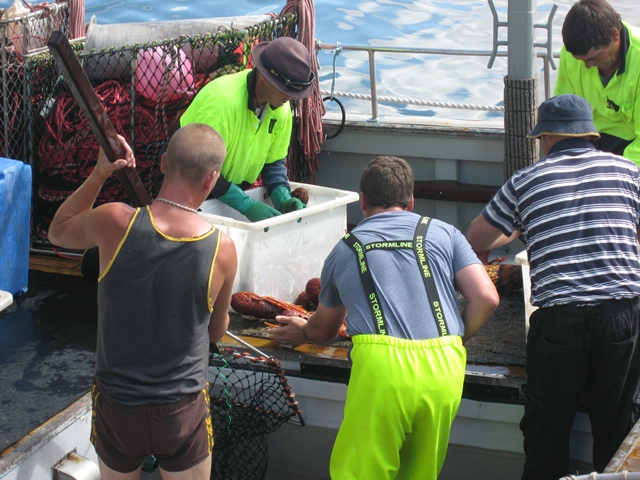
Cray fishermen sorting their catch on the wharf
There are pheasants, peacocks and turkeys running wild all over King Island - they were introduced as sport/food and have thrived. Really strange to see.

This is typical of the cattle pastures in the North of the island.

Yes, that is supposed to be "Quarantine Bay". Michael made some rude comment about it being due to the fact that the only high school on King Island only goes up to Year 10. ;o/

We walked along this river down to Yellow Rock Beach on the North Coast to see the wreck of the Paddle Steamer the Shannon. What the hell was a Paddle Steamer doing out in Bass Strait??


Cape Wickham Lighthouse - the tallest lighthouse in the Southern Hemisphere.

The road to disappointment....

Penny's Lagoon in Martha Lavinia State Park. Apparently one of only a handful of "suspended" lakes in the world. Can someone tell me what that actually means??? ;o)

Memorial at Grassy Mine, overlooking Grassy Harbour. Grassy was a very strange town. In the 1970's it was booming with thousands of mine workers and families. In 1990 the mine closed, and the population plummeted. Its now dotted with derelict, abandoned houses, and had a very strange vibe. It is the best harbour on King Island but we chose to stay at Currie because it has good facilities and the weather allowed us to safely do so.

We are now in the Roaring Forties...

King Island is the resting place of more shipwrecks than any other area in Australia. This is a memorial to one of the most tragic. The wrecking of the Cataraqui in 1845 remains Australia’s worst civil and maritime disaster: 400 emigrants drowned when the ship struck rocks just a hundred metres offshore on the west coast. Half of the victims were children. It was very emotional visiting this site and imagining the terrifying scenes. The vicious coastline was both dramatically beautiful and terrible.


Best name for a town ever!

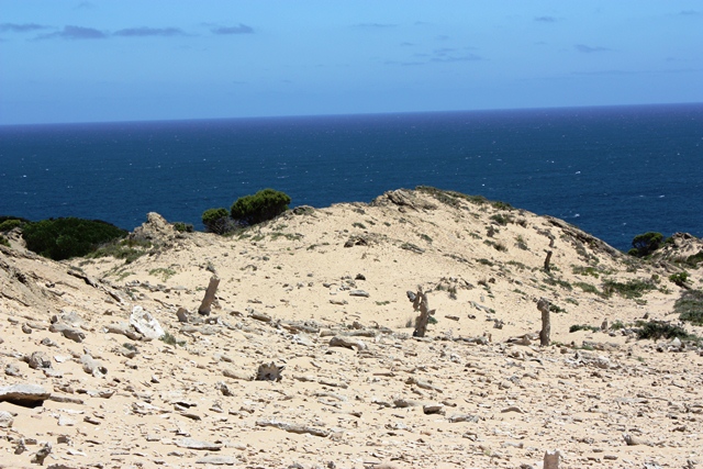
This was an amazing place on the southern coast of the Island - a 7000 year old calcified forest, perched above the Southern Ocean. The features are actually the calcified root systems, not branches.


Our anchorage at Shepherds Bay, Hunter Island.


Yes, I wanna move to Pearshape!!
ReplyDelete'Suspended Lake' not that easy to define. After my 54 seconds on google, it seems to refer to the density of suspended particular matter in the water. ... was it very murky??
Love your pics - very, very beautiful.
Very, very jealous!!!
Im not 100%, but I think the "suspended" lake means it does not seep away into the water table??
DeleteGlad you like the photos Su. I need a lesson from you on how to use my SLR properly - for now its just point and click for me!!
xx